No signal, no problem: Intelligence firm debuts drone tech equipped to beat GPS jammers
A key geospatial intelligence firm on Tuesday announced a new product that can operate drones even in areas where the GPS signal has been jammed – cutting through modern defenses in the age of unmanned vehicular warfare.
The war between Russia and Ukraine presented a unique problem: each military had learned how to jam the other’s GPS signals, meaning their drones would be flying blind. This prompted the latest innovation from Maxar Intelligence, a drone-guiding technology that does not rely on satellite signals from space.
Now, Maxar, a global satellite imagery and geospatial intelligence provider, has the capability to counter GPS-jamming technology through its Raptor system.
‘We’re giving the drones a 3D map, allowing them to use that 3D map of the world to compare it to the video feed and position themselves,’ Peter Wilczynski, chief product officer at Maxar, told Fox News Digital.
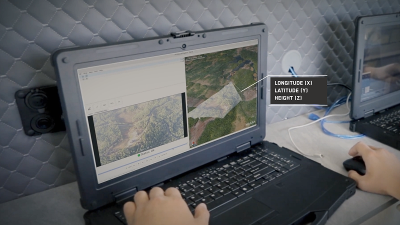
The company’s new camera-based recognition software, Raptor, allows drones to navigate and identify ground coordinates in contested regions where Global Positioning System (GPS) signals have been cut or remote areas where they do not exist.
Raptor can be installed to use a drone’s existing camera and Maxar’s 90 million-plus square kilometer of global 3D terrain data to helps the platform navigate terrain and extract ground coordinates.
While other prototypes of terrain-based positioning preceded Raptor, Maxar believes it has the largest global collection of high-resolution terrain. ‘We’re able to get the accuracy down to the best you can without GPS,’ said Wilczynski.
The software builds off a 3D representation of the terrain it glides over, able to provide an accurate picture at night and at altitudes of 120 meters.
‘This is really the seminal thing that the Ukraine war did for battlefield technology,’ Wilczynski said.
Around the world nations have been developing their GPS signal-jamming technologies to fend off autonomous vehicle attacks. Much of Ukraine is GPS-denied, as are large swaths in Europe and the Middle East. Experts believe that one of the first things China would do if it were to invade Taiwan would be to cut off the GPS signal to isolate the island.
Maxar’s data has been key for Ukraine in fending off Russia – when the U.S. cut off intelligence-sharing, President Volodymyr Zelenskyy’s forces lost access to Maxar’s tracking of the movement of Russian troops and ability to assess damage.
‘From a military planning perspective, the assumption going forward is that in any conflict, GPS is not going to be a reliable positioning system anymore,’ Wilczynski said
In the western hemisphere, GPS jamming has been used by drug traffickers to evade detection and other organized criminal operations.
America’s GPS, once considered cutting-edge, is now at risk of becoming outdated as Chinese, Russian and European systems modernize.
The Pentagon, together with Space Force and Army, have in recent years been scrambling in search of alternatives for when GPS signal is unavailable on the battlefield. The issue has become acutely pressing as adversaries like China and Russia develop their anti-satellite capabilities.
The threat is not contained to far-off conflict zones but also everyday life in the U.S.: financial systems, emergency services and air traffic could all face dire emergencies without access to their satellite systems.
Maxar plans to employ its Raptor technology for both commercial and defense purposes as nations across the globe search for a cutting-edge alternative to GPS signal.